
Local Intake
ATTACHMENT 1
SCHOOL EDUCATION ACT 1999
DECLARATION OF LOCAL INTAKE AREAS FOR SCHOOLS WITH PRIMARY STUDENTS
(Pursuant to Sections 60, 78, 79 and 80)
The Hon. Minister for Education has declared that the local intake areas for the schools listed hereunder shall be as stated in this notice. Children of compulsory school age who reside within the local intake areas stated shall be entitled to attend the school to which such local intake areas apply if there is an appropriate educational program for them at that school. Children who reside outside these local intake areas may apply to attend the school to which such local intake areas apply.
JENNIFER McGRATH, A/Director-General of Education
CHALLIS COMMUNITY PRIMARY SCHOOL (5567)
The following will define the local intake area of this school from 2019:
From the junction of Railway Avenue and Armadale Road, west along Armadale Road (north side included) to the southern extension of Dewar Street, north-west to and along Dewar Street (both sides excluded) to Braemore Road, north-east along Braemore Road (both sides excluded) to Cobar Street, north-west between Firetail Court, Viana Loop, Granada Loop and Salamanca Boulevard to the south-west and Petrel Close, Waterway Cove and Fulmar Way to the north-east, to Seville Drive, north-east along Seville Drive (both sides excluded) to Westfield Road, north-west along Westfield Road (both sides excluded) to Hesketh Avenue, south-west along Hesketh Avenue (both sides excluded) to Fallon Place, north-west along Fallon Place (east side included) to Lake Road, north-east along Lake Road to McNeill Road, north-west along McNeill Road (east side included) to Wungong River, in a generally northern direction along Wungong River to Champion Drive, south-east along Champion Drive (south-west side included) to Railway Avenue and south along Railway Avenue (west side included) to Armadale Road.
Children residing in the following area in 2018 will retain an entitlement to enrol at Challis Community Primary School provided there is at least one member of the family already enrolled at Challis Community Primary School in the year in which the child is applying to enrol:
From the junction of Seville Drive and Armadale Road, east along Armadale Road (north side included) to the southern extension of Dewar Street, north-west to and along Dewar Street (both sides included) to Braemore Road, north-east along Braemore Road (both sides included) to Cobar Street, north-west between Firetail Court, Viana Loop, Granada Loop and Salamanca Boulevard Close to the south-west and Petrel Close, Waterway Cove and Fulmar Way to the north-east, to Seville Drive, north-east along Seville Drive (both sides included) to Westfield Road, north-west along the Westfield Road (both sides included) to Hesketh Avenue, south-west along Hesketh Avenue (both sides included) to Fallon Place, north-west along Fallon Place (west side included) and its extension to Lake Road, south-west along Lake Road (both sides excluded) to Poad Street, south-east along Poad Street (both sides excluded) to Seville Drive, and south along Seville Drive (east side included) to Armadale Road.
WILLANDRA PRIMARY SCHOOL (5279)
The following will define the local intake area of this school from 2019:
From the junction of Armadale Road and Seville Drive, east along Armadale Road (north side included) to the southern extension of Dewar Street, north-west to and along Dewar Street (both sides included) to Braemore Road, north-east along Braemore Road (both sides included) to Cobar Street, north-west between Firetail Court, Viana Loop, Granada Loop and Salamanca Boulevard to the south-west and Petrel Close, Waterway Cove and Fulmar Way to the north-east, to Seville Drive, north-east along Seville Drive (both sides included) to Westfield Road, north-west along Westfield Road (both sides included) to Hesketh Avenue, south-west along Hesketh Avenue (both sides included) to Fallon Place, north-west along Fallon Place (west side included) and its northern extension to Lake Road, north-east along Lake Road to McNeill Road, north-west along McNeill Road (west side included) to Wungong River, in a generally southern direction along Wungong River to Lake Road, south-west along Lake Road to Ranford Road, south along Ranford Road (east side included) to Armadale Road and east along Armadale Road (north side included) to Seville Drive.
FORRESTDALE PRIMARY SCHOOL (5613)
The following will define the local intake area of this school from 2019:
From the intersection of Armadale Road and Nicholson Road, west along Armadale Road (south side included) to Taylor Road, south along Taylor Road (both sides excluded) to Rowley Road, east along Rowley Road (north side included) to Ditton Road, south along Ditton Road (both sides included) to Craddon Road, west and south along Craddon Road (both sides included) and its southern extension to Anketell Road, east along Anketell Road (north side included) to Thomas Road, north-east and east along Thomas Road (both sides excluded) to the Birriga Drain, north and east along the Birriga Drain to Kargotich Road, north-east along Kargotich Road (both sides excluded) to Rowley Road, east along Rowley Road (both sides excluded-and excluding Lentara Place) to Hopkinson Road, north from this point to Forrest Road, west and north-west along Forrest Road (south-west side included) to Twelfth Road, north-east along Twelfth Road (both sides included) to Armadale Road, west along Armadale Road (south side included) to Ranford Road, north along Ranford Road (west side included) to Lake Road, north-east along Lake Road (north side included) to Wungong River, in a generally northern direction along Wungong River to Champion Drive, north-west along Champion Drive (west side included) to Tonkin Highway, south-west along Tonkin Highway (east side included) to Ranford Road, north-west along Ranford Road (south-west side included) to Anstey Road, generally south-west along Anstey Road (south-east side included) to Armadale Road, and west along Armadale Road (south side included) to Nicholson Road.
The following defines an optional area between Atwell Primary School and Forrestdale Primary School:
From the junction of Armadale Road and Liddelow Road, south along Liddelow Road (east side included) to Bartram Road, east along Bartram Road (north side included) to Taylor Road, north along Taylor Road (both sides included) to Armadale Road and north-west along Armadale Road (south side included) to Liddelow Road.
The following defines an optional area between Forrestdale Primary School and West Byford Primary School:
From the junction of Hopkinson Road and Rowley Road, west along Rowley Road (both sides included—and including both sides of Lentara Place) to Kargotich Road, south-west along Kargotich Road (both sides included) to the Birriga Drain, in a general easterly direction along the Birriga Drain to Hopkinson Road, and north along Hopkinson Road (both sides included) to Rowley Road.
The following defines an optional area between Forrestdale Primary School and Harmony Primary School:
From the junction of Liddelow Road and Bartram Road, south along Liddelow Road (east side included) to the junction with Wilga Court, east from this junction to Taylor Road, north along Taylor Road (both sides included) to Bartram Road and west along Bartram Road (south side included) to Liddelow Road.
The following defines an optional area between Forrestdale Primary School and Aubin Grove Primary School:
From the junction of Liddelow Road and Wilga Court, east from this junction to Taylor Road, south along Taylor Road (both sides included) to Rowley Road, west along Rowley Road (north side included) to Liddelow Road and north along Liddelow Road (east side included) to Wilga Court.
CURRENT LOCAL INTAKE AREA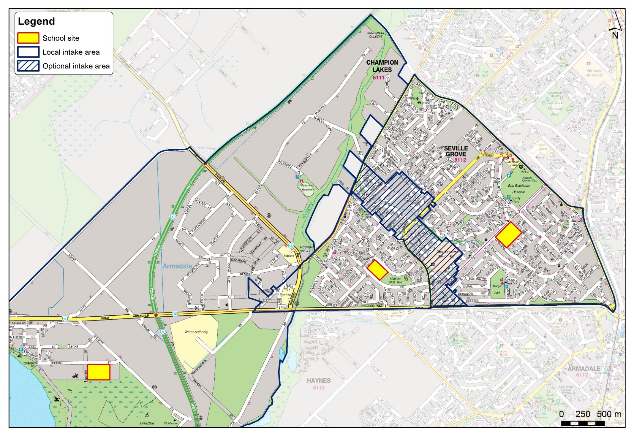
PROPOSED INTAKE AREA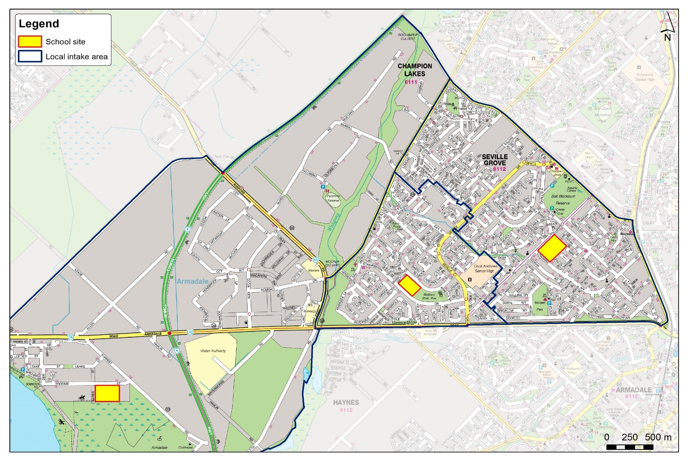
CHALLIS INTAKE AREA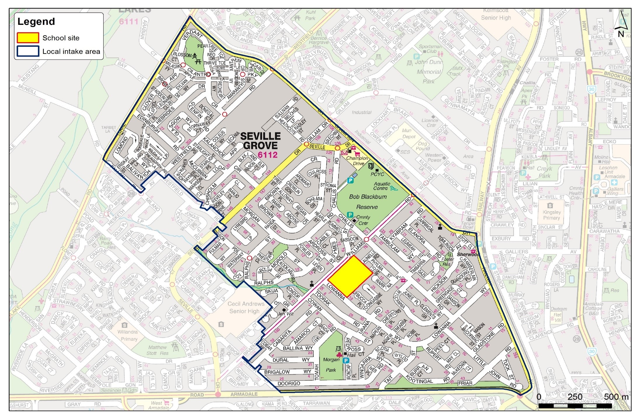
Acknowledgement

© Challis Community Primary School